Thursday, March 31, 2005


Freeride update... I got a new 24" rear wheel for my Kona Stinky. It's a much wider rim, and that let me put a more burly 2.7" tire on. I also had it powdercoated (bright orange!) at Salem Powdercoat. The more sturdy rear wheel means I can huck off of higher stuff without worrying about it tacoing (as easily)! Can't wait to try it out this Saturday! Posted by Hello

you get what you pay for I guess...

The bloglet server had issues. That's the free service that allows people to subscribe to receive email alerts when new posts are made here. They lost my settings for this blog, so it wasn't checking, and anybody that subscribed needs to subscribe again. (Use the form over there on the right...)

Sorry... no wait, I'm not really sorry! It wasn't my fault. And you do get what you pay for... so nothing to really complain about.

Have a nice day.

Monday, March 28, 2005

Quick quote...

It is not the critic who counts: not the man who points out how the strong man stumbles or where the doer of deeds could have done better. The credit belongs to the man who is actually in the arena, whose face is marred by dust and sweat and blood, who strives valiantly, who errs and comes up short again and again, because there is no effort without error or shortcoming, but who knows the great enthusiasms, the great devotions, who spends himself for a worthy cause; who, at the best, knows, in the end, the triumph of high achievement, and who, at the worst, if he fails, at least he fails while daring greatly, so that his place shall never be with those cold and timid souls who knew neither victory nor defeat.

-- Teddy Roosevelt (April, 1910)

Sunday, March 27, 2005


Happy Easter! Posted by Hello

Yesterday, the Basic Training build crew was out constructing a new 5' drop into the advanced dirt jump line. We built this in the morning, and it was ready for testing by noon. I had to fight them off to let me hit it first! I put all of the rungs on and helped build the transition (the landing area - on the picture above that's the grayish rocky part on the right). Worked great - it was a lot of fun trying it out first. I pulled up a little too much on my first try (didn't want to nose in), but my second attempt was smooth - landed just right - the tranny was solid and the run out just right. It'll be a lot more fun once the dirt jumps are built and we can flow right down into the main part of Basic Training. Can't wait to try it again next weekend! It's helping me prepare for a larger drop further up the trails - the "ski jump" up on Granny's Kitchen. That's got a pretty wide gap, but really isn't much bigger than this drop we built. Posted by Hello

Saturday, March 26, 2005


Wendy was on spring break last week, and repainted/redecorated the main bathroom (I helped a bit - but mostly it was her project). It turned out really good. She painted it the same color as the livingroom accent wall we'd repainted earlier this month. It's a burgandy-ish color. Posted by Hello

Here's what the finished bathroom looks like. It's way more stylin' than the plain old white than it was before! Posted by Hello

Friday, March 25, 2005

Croisan Scenic Trail... (part 2)

I sent a message to the Salem Transportation Services Manager to alert him about the fact that someone had put up a fence across the trail. Also asked him if I could place a geocache somewhere along the trail (that was really the reason I sent a message *grin*).

Apparently, the trail is not an "approved improvement to the public right-of-way" but the trail does indeed lay on a public right-of-way - so while they don't prevent people from traversing it (it's not private land), they do control improvements made on it.

Sounds like a gray area. Guess that's why there's so much debate over this trail. Good to know people are welcome to use it for hiking, biking, etc. Just have to get approval from the city first before making improvements to it (i.e. laying down gravel and that sort of thing). For example, the "Friends of Croisan Scenic Trail" got permission last month to add gravel and remove leaves from the path.

The fence and sign was placed by a home owner, and the Transportation Services Manager already discussed this with him - the home owner believes it's placed at the boundary of the corner of his lot. They still need to determine exactly where boundary really is though.

One part of the proposed plan (created by the Friends of Croisan Scenic Trail) is to have an agency research and map the boundaries. That plan will more than likely be presented at a City Council meeting to discuss the future of this trail.

Less gray, and more black and white seems to be necessary to get people on the same page.

Note: Didn't get permission to place a geocache along the trail - have to wait until after the trail is approved as an "improvement to public right-of-way" (at which point it apparently would become an official trail and nothing would really prevent me from placing a cache there).

What I've learned from taking a closer look at this issue is that people sure like to draw lines around stuff. Don't cross this, it's mine. Don't go there, that's where I go. You can do this, but not that.

Guess that's called society. Building cages within cages, and pretending there aren't cages. Learning to squeeze between the bars or that you can simply climb over the cage wall (so you can pretend there's not another cage wall you are still inside of) - that's what it's all about. Stupid cages.

Wednesday, March 23, 2005

Croisan Scenic Trail... conflict?...

There's this trail near where I work over in South Salem that's been around since the 70's, and apparently the home owners with backyards along where this trail is are getting all up in arms that people are "trespassing". The trail is city property. They've all got trails leading down from their backyards to this very nice hiking/jogging trail. The issue is going to the City Council soon. They want to close down the trail for public access.

So today it seemed like a good afternoon to scope it out during my lunch break.

I found a "Private Property" sign snapped off and toss beside the trail, but also encountered some chicken wire fence stretched across the trail with a white plastic sign. I was walking downhill on the trail, and had to go around the fence to read the sign... on the other side it read: "Private Property".

Thought that was odd because I was already on the trail and apparently was walking OFF of the "private property"!

I took pictures.


I continued down the trail to a section of what appeared to be an old paved road. It was overgrown with moss and stuff.

I took pictures.


I continued back onto the trail for awhile... it kept going downhill, and I had to get back since this was just my lunch break.

I took pictures.


Overall, the trail looks excellent for a hiking/jogging trail. It has 1/8" gravel that makes for very hard pack and has a wooden bit of bridge work (only easily ridable in one direction due to some small steps). The trail has good drainage. It'd been raining for a couple of days, but the trail was not muddy or difficult to walk on.

I think that I might place an urban geocache somewhere along this trail. More people enjoying and using this trail, the less likely the home owners will be able to get it shutdown to public access.

As far as a mountain biking trail... It does NOT seem like a very fun trail (in my opinion), in fact, if one were on a bike and bombing downhill - there would be danger to hikers - since in most places it's not easy to jump off the trail (for either the hiker or the biker). However, it'd be a fine grind UPHILL for cross-country riders however - not a steep incline, but you'd feel the burn by the time you reached the top!

This trail is only 10 minutes from where I work, and there wasn't anybody on the trail and it made for a nice afternoon hike.

If only there was a real mountain biking trail just 10 minutes away! That'd make for a great destination to take a mental break during the middle of the day.

Sunday, March 20, 2005


Fields of tulips at Wooden Shoes Tulip Farm near Woodburn, Oregon. Posted by Hello

After church today, Wendy and I went to the Wooden Shoes Tulip Farm near Woodburn, Oregon. Their 20th annual festival started the day before. The weather wasn't too great, but their wasn't much of a crowd either! We'd been meaning to visit a tulip farm since we moved here, and just finally got around to it.. was a good chance to try out my new camera too. Posted by Hello

Candela tulips at Wooden Shoes Tulip farm near Woodburn, Oregon. Posted by Hello

A wooden shoe at Wooden Shoe Tulip Farm near Woodburn, Oregon. Posted by Hello

Saturday, March 19, 2005


Hey! Guess what!? I got an early B-day present yesterday! yup, that cool Digital SLR I've had my eye on for months and months (almost a year now!). Ended up getting a Nikon D70 cuz it had better features than the Canon Rebel XT. It does 1/8,000 sec shutter speed and has built in metering to take richer (color) pics. I took it out today to Blackrock trails with the Basic Training build crew. It was raining all day, but it stopped long enough for me to take my new camera out of my pack and try it out! Here are some of those pics... Posted by Hello

Entry to Blackrock trails Basic Training skinny log ride area (this is the advanced line, the easy line connects from the left... and notice the skinny log drop to right!) It's all fun! Posted by Hello

Basic Training build crew working on section of skinny Posted by Hello

Wade and Rich working on new section of skinny log at Basic Training Posted by Hello

New section of skinny log ride at Basic Training Posted by Hello

Ben riding new skinny log section of Basic Training Posted by Hello

Wednesday, March 16, 2005

My latest gadget desire...

...is fixed firmly upon a digital SLR. Specifically, this beautiful piece of technology:


It's the Canon Rebel XT - an 8.1 Megapixel digital SLR - just came out last month!!!

It can freeze time itself with the 1/4,000 second shutter speed! It's also got a 7-point focusing system (7 places it "looks" in the frame to autofocus) that literally uses AI (artificial intelligent) servo focus "magic" to track a moving subject in the frame!

It also does really great portrait shots too... to capture the first smile on our first childs face perhaps?

Hey, isn't my birthday this month? hint. hint. *smirk*

Quick Quote...

"The more one looks, the more one sees. The more one sees, the better one knows where to look." - Anonymous

Monday, March 14, 2005

Mail-to-blog test...


Found a setting for blogspot that allows me to just
send an email from wherever and it'll post here.
Trying that out now. Makes it easier to send quick
notes - might even work to send cameraphone photos
that way.

Oh, I also changed the comments so anybody can post -
before you had to set up an account on blogspot.
Didn't realize that was setup that way by default.


__________________________________
Do you Yahoo!?
Yahoo! Small Business - Try our new resources site!
http://smallbusiness.yahoo.com/resources/

Come find me...

I hid a geocache at the Basic Training area last weekend. It's now posted on the geocache.com website...

GCN32R Blackrock Boot Camp

...had been meaning to place a cache at Blackrock for months, and just finally decided to get it done. Guess it was sort of in commemoration of wrapping up the '04 season of building on the trails, and to kick off the '05 riding season. I even threw in two copies of the Local Progression Riders Video DVD for first/second finders prizes!

Now we'll see how long it takes for geocachers to wander up there...

Canada calling...

The motherland of freeriding is calling to me...

The North Shore and Whistler freeride park up in British Columbia are on my wishlist for vacation destinations this year! "The Shore" is where freeriding was truly born - splitting the mountain biking pack into two distinct groups: cross-country (those who keep their wheels grounded but enjoy epic long trail rides) and "freeride" (technical challenging trail riding - jumps, drops, balancing on logs, etc). There are dozens of freeride trails in the area of Vancouver, B.C. - these are referred to collectively as the North Shore.

Whistler is a ski resort in B.C. that's got the worlds most popular freeride mountain biking park. They realized early that the "offseason" is really the "freeride season", and opened up part of their mountain (and chair lifts!) to the mountain biking throngs.

We've based the trail building spec used at Blackrock trails on Whistler's trail standard.

http://ww1.whistlerblackcomb.com/bike/

They've opened up new sections of trail this season that'll triple the amount of trails available! There's a new trail called "Freight Train" that sounds really awesome - it's an expansion of the "A-line" they had last year, but extending from the top of the mountain down to the bottom! It takes about an hour to ride from the top to the bottom. I hear you can get months of experience in with one weekend of riding at Whistler.


There's several groups planning trips up to Canada that I plan to hook up with. Already confirmed one trip over Memorial Day weekend, and there's someone else planning to go up end of June. I'm hoping to get at least 3 trips in up to either Whistler or the 'Shore!

I've already talked to Wendy about these trips, and since her sister is now living in Seattle - it's cool we'll be able to drag her along maybe - there's beginner mountain biking trails at Whistler, but the North Shore trails are pretty advanced so we'll see I guess. At the very least, Wendy could hang out in Seattle with her sister, and I could skip over the border into Canada for freeriding nirvana!

Thursday, March 10, 2005

Pictures from last month...

Finally used up roll of B&W film. Wendy took it to CostCo and had them developed today. Below are some that I scanned in! Hope ya like 'em!

Picture of me crossing suspension bridge on Skookum Flats trail - we went to visit Erika on Feb 19th up in Seattle and also went for a mountain biking trip. Skookum Flats is about an hour and half from Seattle (30 miles from Enumclaw, WA). After testing this bridge out, I also got video of me riding across it! Kinda scary since it was icy and 60 feet down to the water below... but good practise for freeriding! Posted by Hello

Worst Day of the Year ride was on Feb 13th, 2005 - it starts at the Lucky Lab Brewing Company and ends there too (after we rode a nice tour of Portland area - about 15 miles - in 60 degree weather!) Historically, Feb 13th is the coldest and wettest day on record for Oregon e.g. the name of the ride! It's an annual event to raise money for local Community Cycling Center - a non-profit that teaches kids to repair bikes and also donates thousands of bikes to needy families. Posted by Hello

Wendy and I next to Lucky Lab Brewing for the Worst Day of the Year Ride (Feb 13th, 2005) Posted by Hello

At the starting area for Worst Day of the Year Ride (Feb 13th, 2005) Posted by Hello

Erika and Wendy crossing the Steel Bridge in Portland during Worst Day of the Year Ride (on Feb 13th) Posted by Hello

Wednesday, March 09, 2005

"Basic Training"...


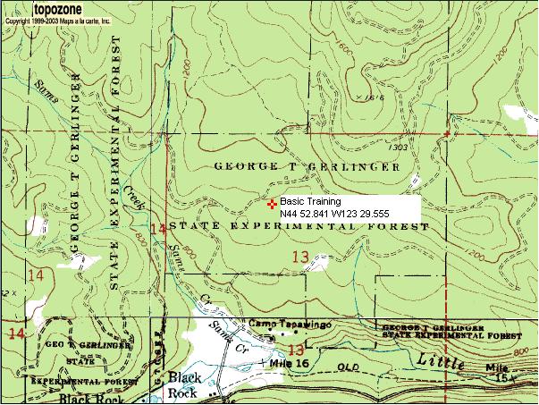
The area at Falls City (about 45 minutes from Salem) where friends and I always go freeriding is called "Blackrock trails". And at Blackrock, we started building an area called "Basic Training". It's not far up the hill - just 15 minutes or so... 'bout a mile from the trailhead. Perfect for newcomers to freeride mountain biking, and it makes a good spot for advanced riders to stop in and warm up for the bigger stuff further up...

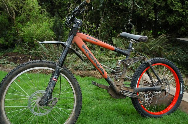
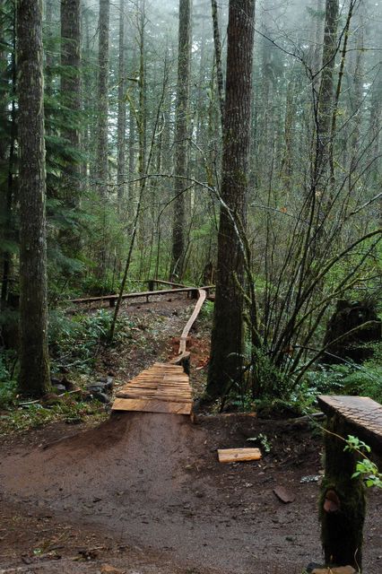
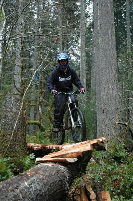
We've got features of varying difficulty. Easy stuff for beginners. Lots of Intermediate stuff. Advanced stuff to challenge skills of more progressed freeriders (like Chris "Montana" shown above doing a 360 from the 4' drop). We've built drops, jumps, burms, skinny sections, see-saws, step-ups... with different challenges thrown in just for skill building twists (like a skinny section that goes uphill). The idea was that we'd have lots of things consolidated into one place where people could "session" (push back up and try it again) - and that's just what we've got done! I've also talked to local shop owner about having a regularly scheduled "skills clinic" that they sponsor - where more advanced riders demo certain skills and talk thru the techniques necessary for group of riders. The area is a great spot to just hang out and ride with family and friends. One of the trail volunteers has even constructed a picnic table out of logs, and we've installed it at Basic Training - actually incorporated it into a line we call the "Lunch Line" (the picnic table makes a nice table top for a large dirt jump - people can either jump the whole table and land on the tranny or short it and land on the table and roll off).

It's been really cool to see Basic Training become a very important feature of the Blackrock trails. And we made it happen...!

The whole "Basic Training" thing came about because for months I kept hearing people say "wouldn't it be nice if there were easier stunts to learn on" (at Blackrock there was a lot of advanced features, and if you didn't have the skills you had to just ride around it... looking up at these monstrosities built in the woods that cast their shadow over you...).

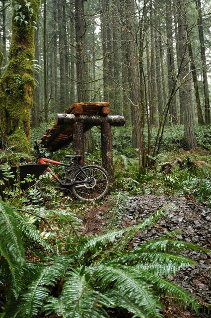
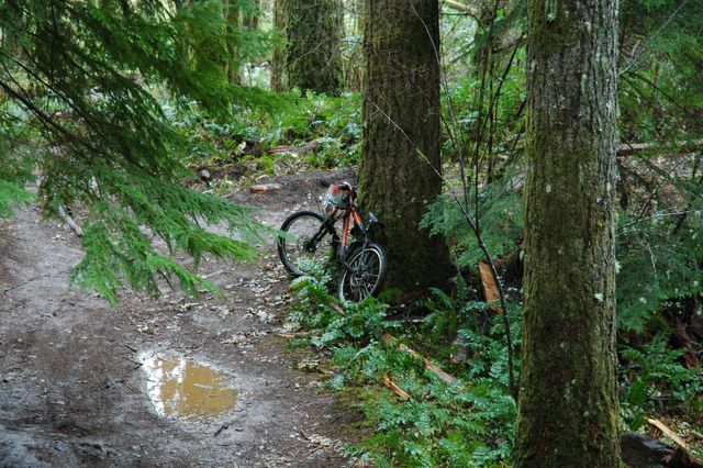
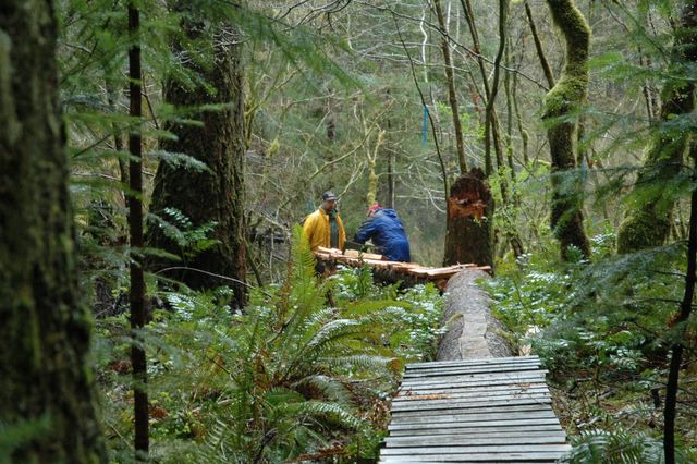
One day I just said, ok, let's build an area for practicing! We scouted for a good area - one that wasn't too far from trailhead which had decent terrain (not too steep to push back up but just steep enough and varying enough to build fun/challenging stuff on). Had areas in mind, but hadn't really looked with an eye to actually build stunts. Looked at a few places, but one in particular seemed perfect - there were even half a dozen snags (blown down trees) nearby which could be used for building material (thanks to an ice storm back in January '04). Here's a picture of the area as it looked before we started building:
We submitted our proposal to the Blackrock Freeride Association and the area was approved by Oregon Department of Forestry in October 2004.

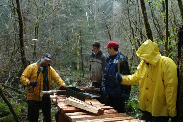
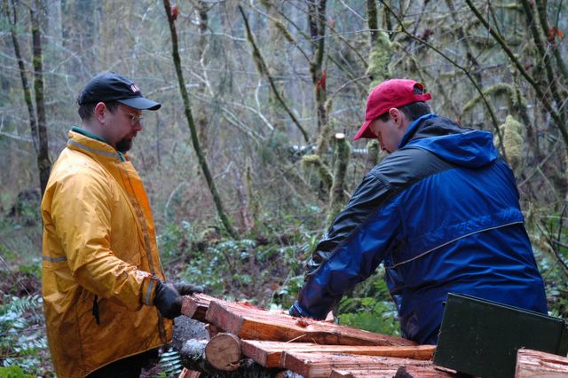
As of today (just under 6 months later), according to the work log, there's been 199 hours of work poured into building Basic Training by dozens of volunteers, and we're probably about 75% done with what was originally planned - and have expanded to accommodate for a whole new line of dirt jumps (we're going to start building them next weekend - they'll tie in nicely). Mostly there's been a core group of builders - myself, Wade Waddell (who works at same office as me), and Rich Bontrager (someone we met on the trails) - along with regular volunteers - Ben Hayes, Chris "Mongo", Joe A, Christian (and sometimes his dad Lee).

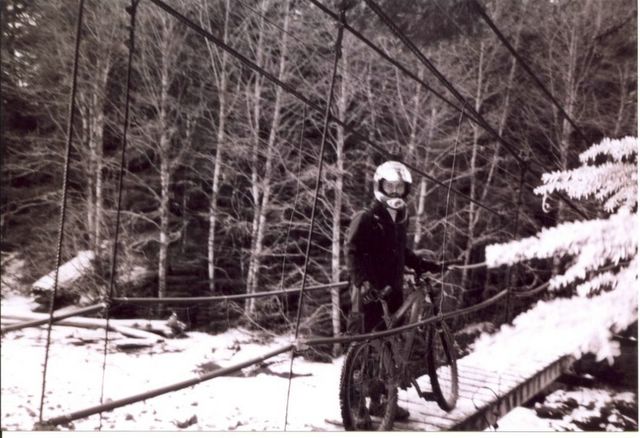
We're about to build a bridge for one of the skinny lines also (where the advanced line crosses over the easier line). And plan to use an ancient Chinese bridge technique that doesn't use central supports. It's called a "rainbow bridge" and creates a nice arch (where the easy trail will cross under). Not sure how it'll turn out, but it will be fun trying to build! (It's a bridge building technique that's over 900 years old - will be cool to incorporate it into our trail). Here's what a rainbow bridge looks like:


Will let ya know how it turns out!

Quote for the moment...

When one door closes, another opens; but we often look so long and so regretfully upon the closed door that we do not see the ones which open for us. - Alexander Graham Bell

This is a topo map of exactly where the Basic Training area is located. Note that the trailhead for Blackrock trails is down by where it says "Camp Tapawingo" and the top of the trail system is up off the map just a bit (somewhere around 2,000 feet at top of Mt Brown). the roads are used for part of trailsystem, but mostly the trails are off into the trees...(and sometimes UP into the trees!) Posted by Hello